Friends Finally, after 5 years of efforts, a vision has taken shape. The effort began with the late Mayor George Michelis and his team in 2010, and was always kept alive by Mrs. Hether. Now it has taken its final form. A few days ago, the work of cleaning and marking a network of 15 hiking trails that cross our entire island from end to end, with a total length of 125 kilometers, was completed. A small backlog remains on one route (Route 7, Diakopi-Panormos) due to property issues, which requires the creation of a bypass route, which the contractor will carry out in the near future, along with the final touches, which are the installation of log steps at certain points on the steep paths. This project, which was implemented according to the most modern European standards, has the potential to put Skopelos on the map of hiking destinations and attract thousands of foreign and Greek hikers, extending our tourist season to the spring and autumn months. The Municipality will do its best to maintain and promote it, but we must all take care of it and protect it, and inform our visitors and customers about it. It is a project funded by the Ministry of Environment with a budget of €360,000 We will do what we have promised. And we continue.
At Last
https://www.facebook.com/share/p/183wvkYnBP
This is a link to the Facebook post written by our mayor in which he mentions our work.
it somehow feels that all roads have lead to the implementation of this project and I’m obviously delighted that it’s come to flouision.
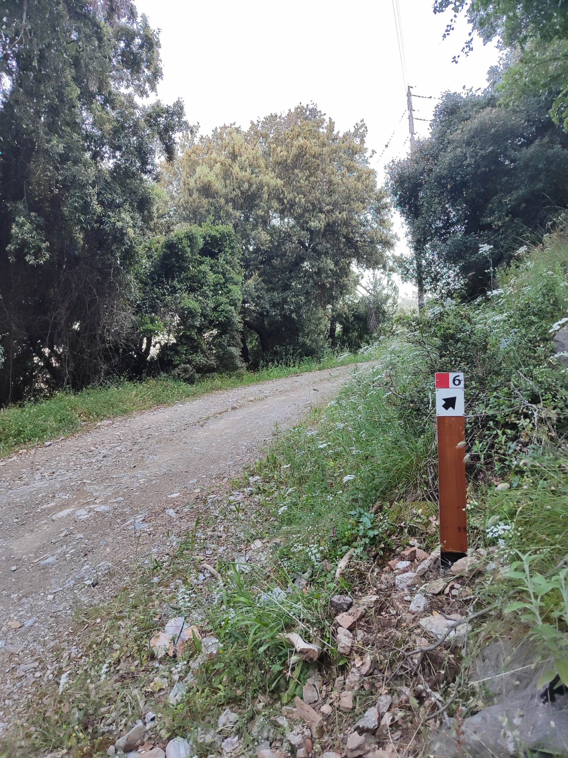
The budget was cut by half which means many things in the original study can’t be carried out. For example three years maintenance, renovation of broken cobble, engineering of certain portions of track. But the signs are going up and the metal maps soon will be.
The contractors who are carrying out this work are connected to Terrain editions maps and they have made their own numbering system to tie in with their map. So their trail numbers are not the same as those in the Skopelos Trails guide book. We will be adjusting ours to fit theirs at the next rewrite.
Not every single trail we have reopened is included in the Project but there are enough to keep the visitor occupied and additional trails are on the map. The signed routes are marked on the map in pink.
So what started out some thirty years ago with me with a pair of clippers, clearing vegetarian so I could walk my dog and getting hooked on finding another piece of cobble, has come to this. I couldn’t ask for more.
Baby it’s cold outside
After much deliberation and disappointments, I’ve decided to ‘freeze’ Skopelos Trails for a year.
Tax is still being paid to date even though I have hosted no volunteers and have carried out no trail clearing. As soon as the freeze is official, this burden will cease.
At the time of writing, the Trail Project is still in the air. The latest start date was cancelled with three days notice.
If anyone would like a guided hike, I am prepared to do this on a private basis; just email or WhatsApp me. The mail order service will continue as usual as will the information service. I will not be doing any trail maintenance though so please don’t contact me on this subject as it will only make me feel guilty! I will also not be issuing a monthly new letter unless it is some Very Important News.
If you find yourself in the Karia area, do drop by. I am near Profitis Ilias church.
Thanks to everyone who sent a donation. May you be blessed.
Heather
Patience is a virtue
We’ve had no volunteers recently as I am moving home into the countryside. It’s taking forever.
We continue to pay the tax debt monthly and Thank You so very much to the very kind people who donated. May your god bless you. If anyone else would like to help, there’s a Donate button on my home page.
On a positive note, the trail project is due to begin on 13 April would you believe (I can’t!) But after five years of waiting, Stephanos the independent trails architect, has been given the green light. I will be directly on the ground involved with this.
2025 REVIEW
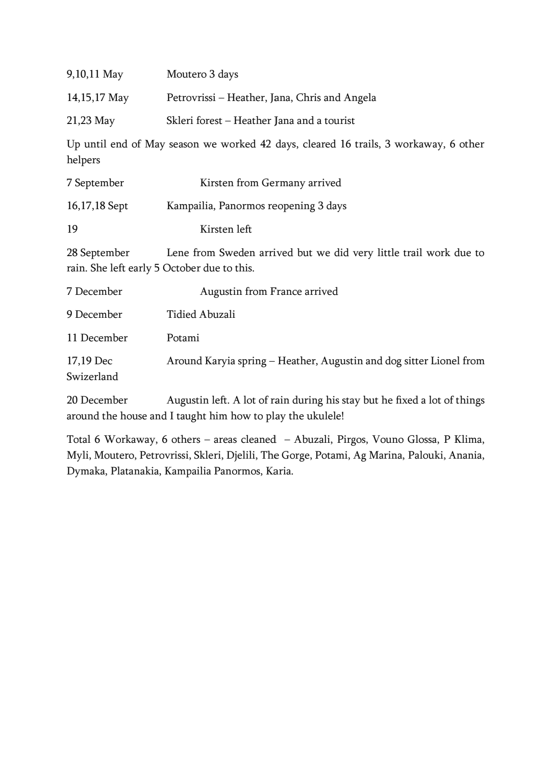
Below are details of how many volunteers we hosted and how many trails we reopened and cleaned in 2025. Bearing in mind we no longer have teams of volunteers as before, we cleaned more than I imaged.
In other news, it seems that our now ex accountant had never informed us of our tax situation resulting in seven years of non payment of tax. Plus a penalty, we are now trying to pay off this enormous debt. It seems that even if you have no income, you still have to pay tax. This has made us think hard about the future of Skopelos Trails. Soon, we will have no spare room in which to house volunteers as we are moving to smaller accommodation. Someone else wanted to take over the reigns but they have no spare accommodation or money to pay the regular tax of 400 euros a year we now realize we have to pay. Yes, my friends, on top of buying all the equipment required, hosting and working alongside volunteers and paying for their meals, paying for petrol for the machines and for the car as well as website expenses, it seems the gods are still not content.
What is tchipero
I’m asked this question many times and here is your answer!
https://www.instagram.com/reel/DRXGxN1iDZc/?igsh=MW55N3ZiM2wxbHdycA==
Not all tavernas sell tchipero or are equipped to provide the wealth of small, mezze plates served with each bottle. Remember, that as well as going through the ritual of ice, tchipero and maybe water, the order of importance is: conversation, eating and drinking. And because the mezzethes are put into the middle of the table for sharing between everybody, be mindful how much you are eating; some people are slower than others.
As well as the choice of with or without aniseed (glikaniso – which turns cloudy when water is added) tchipero is made from many different types of grape (and occasionally plums).
In the past, it was used for medicinal purposes, being put on the gums of crying babies or rubbed onto the chest to ease coughs and colds. It was also diluted into ‘fruit of the spoon’ to make a liquor.
It’s all about having fun in the company of friends. The more the merrier!

November News
Having been advised not to arrange volunteers for this month due to the imminent start of the Trails Project, I haven’t actively been looking. So, of course, the start date has yet again been delayed as the papers have been sitting on someones desk waiting to be signed and returned. We are so close now, I can’t say more.
The last trail to be cleaned was Abuzali on 15 October.
Lene, a retired nurse from Sweden came to help at this time but it rained every day and she got so bored with lack of work, she left! We did manage to go round and check on some of the Geocaches, remove a couple that weren’t working and place a new one that got found two days later!
On 12 October, I GPSed a long circular hike starting from Milos, then Ag Konstantinos, down to Glysteri, up to XTA, Chickpea, Pera Kariya, Kriavrissi, The Gorge, Djelili, Prof. Ilias and back to Milos – 13k. A route for the next edition of Skopelos Trails.
The next group hike, weather permitting, will be on Sunday 16th. I’m thinking Mill on the Hill via Kimissia, returning by municipal bus.
We are now gathering information for our next publication which will be about Mammals and Bats. If you have any high resolution images of mammals or the fallow deer, please contact me. You will receive full photo credit.
Skopelos Trails: A British woman uncovering — literally — paths of Greek island’s simple past
THIS AND THAT
On 17 September 2024, the mayor wrote to inform me that the Ministry had approved 600,000 euros for the Trails project, submitted some 4 years previously. I was then informed that the work had been put out to tender, the result of which would be by the end of June this year. I have now learnt that the amount of 275,000 euros has been allocated for the trails project and will be finalized by the end of September. Draw your own conclusions.
The first volunteer of the autumn season arrives on Sunday. Her name is Kirsten and she’s from Germany.
I’ve been asked several times, even though it is mentioned on this website, where my books can be purchased locally. Hoharoupa stationery shop, Puesto coffee shop are open all year round and carry stocks plus Juices & Books (summer only).
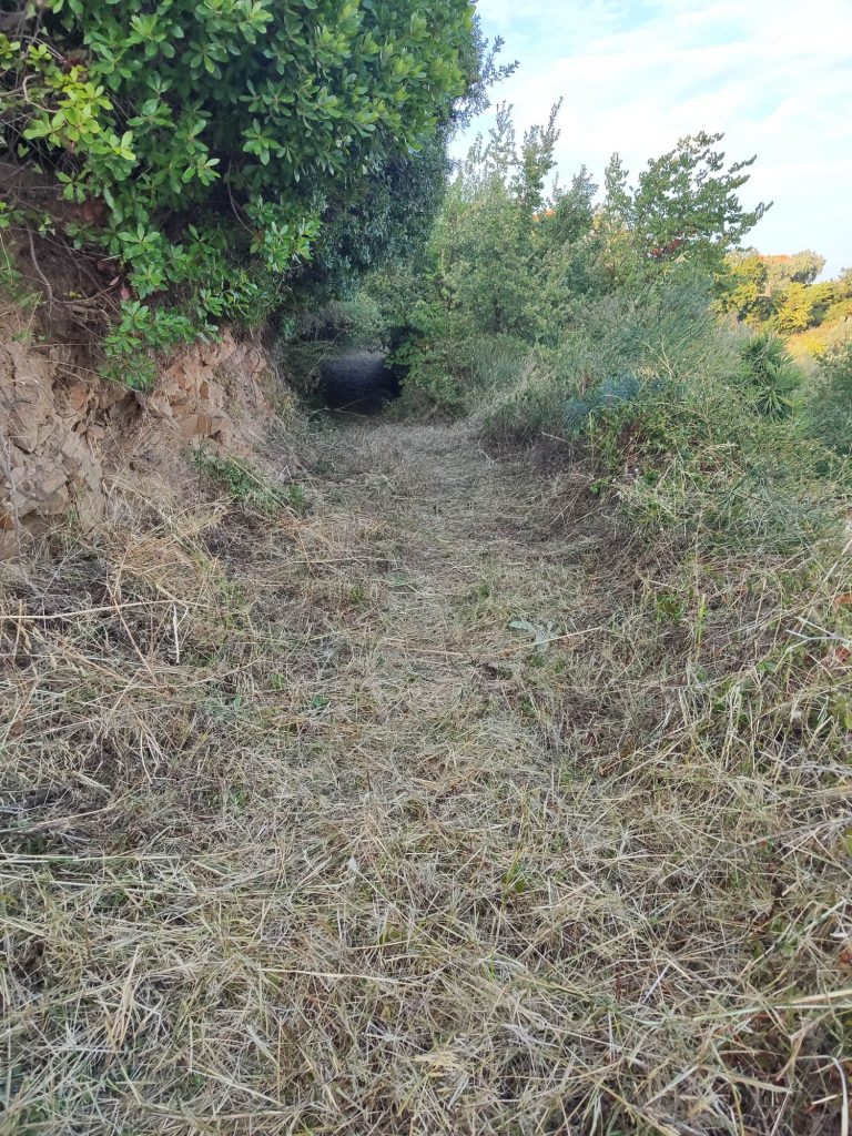
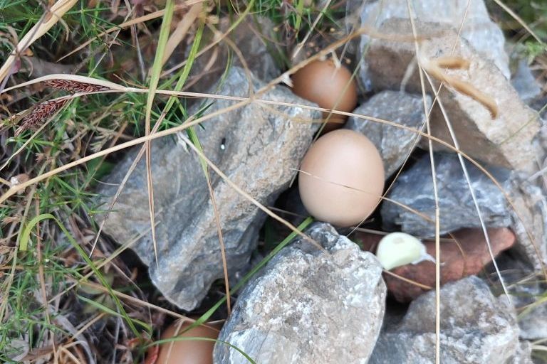
For those who don’t subscribe to social media (those who do can stop reading now) I have been finding eggs placed in the same location in Myli over a period of about 2 years now. On hiking this trail recently, there was not only two more eggs but also a clove of garlic. Among the comments, Sue has suggested it may be a folklore. Such things are often peculiar to certain countries and I’ve no idea if this one is for Greece and apart from the Blue Eye and strings of garlic, I’m not aware of any other protective measures folk here take.
Updates – A Walk Down Memory Lane
It’s been too long since I looked through the Skopelos Trails Walking Guide book in order to update it. Since the 4th Edition was published ten years ago, many changes have taken place. I’m also wondering whether to keep the additional information regarding fauna, bearing in mind we have published detailed books on the same subject (and flora at some point in the near future). What do you think?
So I have systematically read through the entire book and have the following comments:
Inner sleeve email is now skopelostrails1@gmail.com. My request about not using the book for profit or gain has fallen on deaf ears. You know who you are. The PLEASE NOTE box can now be ignored as these routes are regularly maintained. Under Jargon, you can add: Calderimi – Old cobbled ways. The original highways. Kalivi and kalivia (plural) – stone countryside cottages used as shelter during harvest time – they’ve nearly all been renovated and many are now AirB&B.
Any reference to Nastas tchiperadiko should be ignored. It’s been closed for years now. The family brickworks kiln was dismantled too. The son of the original owner carried on this popular business though which is now called Dimitraki and can be found on the monastery road. For the moment at least, a better landmark is the ACS Courier service that is situated at the Ag Reginakis junction.
Walk 1. The Old Stafilos Road, as predicted, is now entirely asphalted (even covering bits of old calderimi) as is the road to Ag Marina spring. After pic.3, I recommend you keep left, passing the boat yard after which you enter a beautiful area of wiggly trees called Lalaria. At the curve, turn right (ahead is a dead end) and up the slope, emerging just opposite the house in pic 4.
Walk 2. The mills are no longer visible having been consumed by foliage.
Walk 4. Agnondas. This route will not be appearing in future editions. Better to use the Kokala/Heliport route up and drop down to Agnondas opposite the goat station.
Walk 6. Glysteri is now an ‘organised’ beach with all that brings with it. As predicted, it is no longer ramshackle. Image 18 of the Kastro car park is historical. These days it is always full of cars and the wording Kastro on the wall has been painted over. This place was a famous traditional music venue from a time that sadly no longer exists. Also Remetzo (up on the left of pic.19) We used to go there not only to drink tchipero but to help Rigas tread his grapes. At least the M4/M25 motorway signs referred to have been removed. However, the mayor thinks the discrete replacements are too small! I know which I prefer.
Walk 7. The covered seating area at Djelili was destroyed in a flood shortly after construction. The T Trails will be phased out eventually (see separate post on this site).
Walk 8. The first mill referred to on this route has sadly been renovated beyond recognition and its sluice above has been filled in. The second mill house has survived though. My ginger-haired friend (pic.35) has gone grey! He still has a dog though and this one also barks.
Walk 9. Believe it or not, the pile of sand referred to (pic.43) is, ten years later, still there!
Walk 10. Tria Plantania. Stis Stathou spring was fenced the last time I was there.
Walk 11. The flat roofed house now has a tiled roof. I haven’t cleared the ‘natural’ route for years. Since the Petrovrissi spring dried up, it is no longer regularly used. The other route was bulldozed and now a few new builds have sprung up. It’s really difficult to walk down as it’s so steep. Better when it was a natural trail meandering up the mountain and roots were our stairs.
Walk 11. Return route 3. The trail behind Vromoneri was always a favourite of mine but since the occupant of a kalivi situated beside it installed a huge dog (as well as pigs and goats) we’ve been unable to maintain it.
Walks 13-16 The Monastery area. The old Dilinia taverna building was raised to the ground and a modern structure has taken its place. For updates concerning the occupants of the monasteries, please read my previous post here.
Above Mon. Sotiros, just below the E Mana tou Nero spring, Spiro the goatherd no longer has his camp. He still looks after his goats though, day after day. Nikos, the other goatherd with whom he shared Palouki, has retired and did not pass on his herd. This is rather worrying as it means the trail to the peak will slowly grow over. Time will tell. The curve above Mon. Sotiros is called Anamniseis (Memories). The trail just above Anamniseis corner which emerges onto the Lower Mast Road, does not continue on opposite. You have to turn right onto the LM road until the end and pick up the trail to the summit there. You can also go straight ahead where there’s a goat trail down to Ag Marina – for the moment at least. Towards Taxiarches, the terrible motorway signs have gone (pic59). Beyond Taxiarches, it is intended to forge a trail to enable a circular route.
Walk 17. Kimissia/Panormos. Opposite Moutero church, the pole where my sign was hung, was sawn down. The sign is now on the olive tree. The steps at the other end of this section have gone and replaced with a slope. The road through Moutero is now asphalted. Pic108. This municipal road has been kidnapped by the owner of the villa at the end of it. He is also discouraging hikers from using this route. The situation has yet to be resolved but is ongoing. Take your chances as it’s not fenced or continue on the main road until a signed dirt road on the left, continue by the goat sheds and down to sea level. Unfortunately it’s a lot longer and not as shady.
Walk 18. At the top of Anania hill, the road has been asphalted, covering a portion of very old calderimi. What to say? No trail was ever found after Platanakia. It must have been a track that closed shortly after the resin collectors ceased using it.
Walk 19. Sendoukia. The motorway sign has been removed (pic.74) but tree culling in the area has make the place look rather ugly. You could return to town via The Adventure Trail. Refer to the Terrain map as to its location.
Walk 22. Old Klima’s aluminium roof is now made of wood (see my post about the T Trails). The wooden bridge on the way down to Loutraki is now made of cement. A lot of time was spent on reopening this portion of trail as it had been closed for many years and was being used as a general dumping ground. The Avra hotel is now called Natura Luxury Boutique hotel. The old mill house beside the stream is a pizza/café called Petrino. There’s a short trail beside the steam at the end of which is a beautiful waterfall.
Walk 23. The Three scarecrows were not maintained after so many years and have disintegrated. Such a pity. Put there by a local eccentric, their clothes were changed regularly and items like a transistor radio, were placed in their hands.
Walk 24. After Magdalene died, her bakery was sold and the property renovated. There is no sign of what this special house used to be. The complex of buildings that were the olive press, were sold and renovate. There is now a picnic area beside the church. The majority of derelict houses have been renovated. In fact, the whole village vibe has changed. The annual street party has stopped and nearly all of the folk who bought and renovated in the 80s and 90s have moved on, resulting in a new generation of inhabitants who have a totally different ideology.
Walk 25. The small café by the bus stop and church is now a taverna. Agnanti restaurant has quite a reputation these days since it was featured on a Jamie Oliver TV programme. The church square up is no longer frequented by the old men of Glossa. No more backgammon. No more lingering for hours over a coffee, beer or tchipero. No longer political discussions. Those days have sadly gone. I never got round to reopening the trail from Barba Stelios’ place down to Perivouliou. The main road is now asphalt. I’m not sure if the trail by the shrine in pic.94 is open.
Walk 29. The road to Keramoto and beyond is now asphalt.
Walk 33. Until the issue at Moutero is settled, this route is closed.
There are new routes that we’ve found and reopened since the last publication plus a planned long-distance trail around the island. As soon as the current stocks are exhausted, the 5th edition will be published.
BITS & PIECES
Guided hikes have had to be suspended due to the intense heat; even evening time doesn’t cool down enough. I’m sorry to all those who have contacted me wanting a guided hike but I really don’t think it’s a good idea. And to those who want to see the bridge at Kriavrissi – there is no phone signal in the Gorge, the narrow trail we created is crumbly and should you fall, you will certainly break something or worse, as it’s a long way down. The bridge itself should not be walked upon.
The Trail project for signs and maps was submitted in 2021. After the field work, a study was created and went through the various government departments for approval and in September 2024, €600,000 was allocated. In January of this year, it went to auction to see who would carry out the required work. The result was supposed to have been published by the end of June. That has been and gone and I still haven’t been informed of the outcome.
In preparation for the next Skopelos Trails publication, the theme of which will be Mammals and Bats of Skopelos, we are looking for images of any mammals, dead or alive. So that would include, hares, hedgehogs, martens, rats and other rodents. A GPS location of where the image was taken would also be very handy. A photo credit will be given for any images used. Also, a reminder that any horned viper sightings are also required for use by the University of Thessaloniki Biology department.
Learn some local names: Dymaka – near Ag Reginos Pirgos. Vothana – the pond near the Skopelos Experience, Loutsa
Thanks to George Papalapas who has repaired and restored the vandalized bench at Michalakis. What to say about the brain-dead idiots who damaged it. …